News
MyNorthwest: All over the map: meet me in…West Edge?
Posted on
This story was originally published by MyNorthwest on Jan. 26, 2024
If a friend asked you to meet them in downtown Seattle in “West Edge,” would you know where to go?
Here at “All Over The Map,” we obsess over official names for places, and even more over the unofficial nicknames that, for some reason or another, stick – or don’t stick – to particular places. That’s why we’ve talked about Cap Hill, Sodo and Uptown, and even what we hear some people calling Ess-Eee-Ay airport (whatever that is).
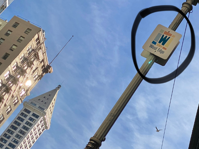
Along First Avenue near Madison Street are metal signs announcing the “West Edge” neighborhood, mounted high up on lampposts on both sides of the street. Photos of those signs posted on social media earlier this month drew dozens and dozens and comments.
One comment was from King County Executive Dow Constantine who listed several obsolete local place names he still uses – like “Lower Queen Anne” for what many people now call “Uptown,” “the Counterbalance,” for the steep hill on the south side of Queen Anne Avenue, and “the Dump” for the parking area along Montlake, south of University Village and east of the UW campus.
KIRO Newsradio reached Executive Constantine by phone and asked him what he remembered about the origins of West Edge.
“You know, I heard about it along with everyone else,” Executive Constantine said. “It was in the paper and I think they hung up signs down at First Avenue. And you know, it didn’t necessarily seem any stranger than any of the other nouveau names they’ve tried to hang on neighborhoods.
“But it doesn’t seem to have ever caught on,” Executive Constantine added.
Digging into online archives of Seattle newspapers via Seattle Public Library, multiple stories reveal that the naming of West Edge was announced at a special event on September 8, 2001, just a few days before 9/11. The naming effort was led by the Downtown Seattle Association (DSA), with a public process managed by consultants, and participation from local merchants, residents and property owners.
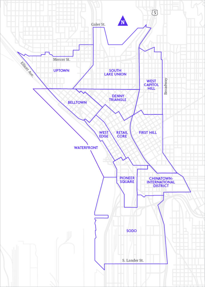
In 2024, DSA uses names for six downtown neighborhoods in what’s called the “Metropolitan Improvement District” (MID). That’s an area where business and property owners contribute financially to support marketing efforts, maintenance of public areas and other improvements. Before 2001, DSA referred to the area in question as “the 1st/2nd Avenues Neighborhood” – so perhaps it’s easy to why they wanted to find something catchier.
For the record, the boundaries for this narrow north-south strip of land are Cherry Street on the south, Lenora Street on the north, Western Avenue on the west, and Second Avenue on the east.
DSA worked with a firm called Tip Top Creative. Debbie Campbell, now retired, was the owner and operator of Tip Top.
After being contacted by KIRO Newsradio, Campbell checked with former colleagues and then gathered and shared much of the history of naming West Edge.
In a long phone conversation, Campbell described multiple focus groups, and the work her team did to come up with several names along concepts for logos. Through the multi-month process, the ultimate choice was “West Edge” – for being in the west part of downtown, and for being edgy and hip. For example, Campbell said the Seattle Art Museum, the Harbor Steps and Benaroya Hall are all located in West Edge.
Some of the other names that were also under consideration were:
“The Blocks” – since there are 26 square blocks in that area.
“The Steppes” – a distinctive spelling and a nod to the Harbor Steps and seven other public staircases in the neighborhood.
“Chenora” – pronounced ‘chuh-NOR-uh,’ for the Cherry Street and Lenora Street boundaries (though it does have a certain movie monster feel to it – maybe because it sounds too much like “Gamera”).
More than two decades later, while West Edge never really caught on, it also has simply not gone away.
It’s still used by DSA as the name of one of their MID areas, and “West Edge” is also present in the names of multiple residential buildings and at least one parking garage within those “Chenora” boundaries. Also for those who appreciate these kinds of details, those other DSA MID names include Belltown, Denny Triangle, Pioneer Square, Retail Core and Waterfront.
Debbie Campbell of Tip Top Creative is rightfully proud of the work she and her colleagues did on the naming project, and she’s philosophical about “West Edge” having not exactly becoming a household name.
“I think we did a good job,” Campbell said. “I really think the name was appropriate for the neighborhood. I liked the logo, and people responded to it. I think it died for lack of traction.”
KIRO Newsradio asked Dow Constantine if he isn’t at least partly to blame for West Edge not catching on. Isn’t part of his job to lead the way and embrace these new names for neighborhoods and communities in King County so that residents will follow?
“No, I refuse,” Executive Constantine said, chuckling. “I mean, some of them make perfect sense, and that’s fine, and things are gonna change with the times.”
“Some people are going to call things what they want to, but I’m going to call them what I think they ought to be called,” he continued. “And if people think I’m being old-fashioned, that’s fine by me.”
One school of thought is that the act of naming that area West Edge (or naming it anything, for that matter) may simply have been ahead of its time. For new neighborhood nicknames to stick, it might require a certain density, or a certain critical mass of people who need that name to differentiate where they live and work.
In the 2000 U.S. census, a little more than 50,000 people lived in downtown Seattle 24 years ago. The most recent data from DSA said that number has more than doubled, and there are now more than 106,000 residents downtown.
That new number suggests that it might not be too late for West Edge to still catch on, because of the density, of course, but also maybe with a little bit of “retro traction” thrown in. Isn’t something that happened 23 years ago – and which is now somewhat esoteric – finally ripe for being discovered, adopted and then exploited by hipsters, influencers and others who mine the recent past for cultural inspiration?
Failing all of that, one commenter suggested bringing back the name “Magic Carpet Area.” That evocative moniker was King County METRO’s brilliant 1973 name for what eventually became the now long-gone “Ride Free Zone” on downtown buses, and which encompasses much of what almost became – and might still become – West Edge.