News
The Urbanist: Seattle waterfront park project finally enters its home stretch
Posted on
This story was originally published in The Urbanist on March 20, 2024.
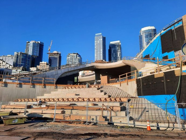
After years of construction disrupting the entirety of Seattle’s waterfront, an end to jackhammering and a final grand opening is finally in sight, with the city’s powerbrokers ready to take full credit. On March 7, the Downtown Seattle Association [DSA] hosted its annual “State of Downtown” event and a major theme was the hotly anticipated grand opening of downtown’s new and improved waterfront park next spring. Backers expected the new park and aquarium to be a jolt to the local economy and a showpiece for the city.
The speaker program included Joy Shigaki, CEO of Friends of Waterfront Seattle, and Leslie Koch, a donors’ representative with Elliott Bay Connections project, a public-private partnership to extend park improvements farther to the north. Both talked up the transformative potential of the linear park, with the new Seattle Aquarium and the Overlook Walk connecting it to Pike Place Market expected to open next year. The new pedestrian connection will join the new Marion Street overpass as a way to access the public spaces along the waterfront without dealing with the busy freight corridor that is Alaskan Way.
“The Overlook Walk [is] the real sweet spot and a selfie spot that’s going to give you the experience of a 360-degree views, the same height as the viaduct, for those of you who are really missing those views driving during the morning,” Shigaki said. “People talk about that a lot.”
Already elements of the new waterfront are coming online. A new Pier 62 park opened in 2020 and an overhauled Colman Dock ferry terminal and a next door Pioneer Square Beach Habitat opened last year. The new waterfront Alaskan Way Boulevard is also open as is a new four-lane Belltown connector called Elliott Way — the City gave the pairing of streets an honorary Lushootseed name of “Dzidzilalich.”
The Friends of Waterfront Park has been heavily programming Pier 62, with activities like giant chess boards and mini soccer fields in place on most days, and fitness or dance classes and musical performances scheduled throughout the year. “Over a million people have come to Pier 62, and it has been a reminder of how parks can be transformative that they’re made for and they make for dynamic, democratic cities,” Shigaki said.
It’s been a long road to get here. Shigaki thanked the crowd of dignitaries from leading downtown businesses and nonprofits for bearing with the decade plus of construction impacts that brought forth the park and associated infrastructure. Seattle’s new waterfront park was made possible by tearing down the Alaskan Way Viaduct, an elevated double-decker highway that carried roughly 100,000 cars per day at its peak. The way the region opted to accomplish this was to dig a nearly two-mile highway megatunnel underneath the city to replace the bulk of the viaduct’s highway capacity, which added to the construction time, especially after a three year delay to extract and repair a busted tunnel boring machine, which had been the world’s largest.
“Nationally, we’re seeing this trend of reclaiming old infrastructure projects, highways, double-decker highways, railroads, to be able to reclaim the beauty of our cities from what they once were,” Shigaki said. “And Waterfront Park is going to be part of that renewal, but it’s going to be part of the revitalization and part of creating a place that everyone sees themselves in and memories to be created.”
While local urbanist leaders like Cary Moon and former Mayor Mike McGinn argued the highway tunnel was not necessary and the focus should be on transit, pedestrian, and park improvements alone, ultimately highway tunnel boosters won out and have sought to frame the tunnel as inevitable and necessary for the park plans since. Of course, Moon, McGinn, and the larger People’s Waterfront Coalition movement against the downtown highway in either an elevated or buried form received no mention at the event.
“This extraordinary, double-decker highway cut across the most beautiful part of our city, like the Embarcadero in San Francisco, like other cities across the nation. It was not about human-centered design. It was about disconnection. But the audacity of the vision after the 2001 Nisqually earthquake, the conversations even before that was what happens when you build a new tunnel.”
Before the viaduct replacement project, the hulking highway polluted downtown with noise and air pollution and interrupted the flow of people from downtown to the waterfront. Now downtown finds itself relatively unobstructed and connected to its unique Elliott Bay waterfront — though the overbuilt Alaskan Way roadway, eight lanes near Colman Dock, isn’t the most welcoming sight to visitors arriving at downtown’s south end.
Taking a trip down the annals of Seattle history, Koch pointed to the foundational vision of the Olmsted brothers, the acclaimed landscape architects that designed many of Seattle’s major parks and parkways (ditto for most other major American cities). In 1903 a group of civil leaders wanted to make Seattle a beautiful city, she noted, “And they hired the Olmsted brothers. And as we all know, pick a park: Seward Park, Woodland Park, what would Seattle be without the Olmsted designed parks, and the Olmsteds really recognized what makes Seattle unique and gorgeous… 120 years ago, [they said] the primary aim should be to secure and preserve for the use of the people as much as possible in these advantages of water and mountain views.”
The Olmsteds’ vision included a world-class waterfront park for downtown, which has gone unrealized until now. Partially this is due to the lack of major parcel of open space in any prominent section, and also because the connections to the surrounding areas were relatively weak and short on pedestrian friendliness. 1974’s Waterfront Park, funded by the Forward Thrust ballot measure six years earlier, was the first major public park along the waterfront, a park that the waterfront redevelopment is completely rebuilding.
The Elliott Bay Connections effort aims to address that with an infusion of $45 million in philanthropist donations to improve the trail from Interbay all the way to Pier 62 and add more plantings and amenities in Centennial Park and Myrtle Edwards Park, which composes the waterfront through the Queen Anne foothill sections. The plan calls for replacing old waterfront streetcar tracks with a landscaped multi-use trail to help handle the expected walking, rolling, and biking traffic and beautify the street. Those improvements are promised by 2026, in time for the World Cup soccer matches that Seattle will be hosting.
“What people don’t recognize, perhaps, is that the Olmsted brothers also had a vision for a waterfront park on the other side of the lake on Elliott Bay that was never realized. So when we think about the inspiration and vision for reclaiming the waterfront for all of us, it actually goes back that long, and then as we looked ahead from 1903, there were many generations of civic activists in this community who advocated for the removal of the viaduct, and taking the waterfront back for the people.”
The Olmsted vision will take another big step forward in 2025, and Seattle will be better for it.